
Bibliothèque de designs
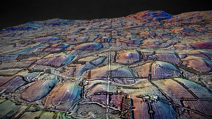
SD67 (dsm) - 3D LiDAR landscape
par NOWTAG
GratuitCC BYSketchfab
100 sqkm enhanced LiDAR centred on SD 6500 7500 between Kirkby Lonsdale & Ingleton in Westmoreland (Cumbria) and North Yorkshire. Includes part of the Yorkshire Dales National Park. 3D model from enhanced LIDAR (DSM, 1m) © Environment Agency copyright and/or database right 2022. All rights reserve
Ce design est hébergé sur Sketchfab. Ses fichiers se téléchargent depuis ce site, sous la licence indiquée.
| Licence | CC BY |
|---|---|
| Source | Sketchfab |
| Designer | NOWTAG |
| Attribution | NOWTAG on Sketchfab · CC-BY 4.0 (attribution required) · Attribution required |
| Tags | landscape, lidar, dsm, cumbria, archaeology, yorkshire-dales |
100 sqkm enhanced LiDAR centred on SD 6500 7500 between Kirkby Lonsdale & Ingleton in Westmoreland (Cumbria) and North Yorkshire.
Includes part of the Yorkshire Dales National Park.
3D model from enhanced LIDAR (DSM, 1m) © Environment Agency copyright and/or database right 2022. All rights reserved. Vertical exaggeration x1.5
Enhancement of the LIDAR was carried out using tools made available in the QGIS plugin, Relief Visualization Toolbox. Kokalj, Žiga & Hesse, Ralf. (2017). Airborne laser scanning raster data visualization: A Guide to Good Practice.
3D landscape model made using the QGIS2threejs plugin for QGIS.
Publiez vos designs
Importez des fichiers STL, 3MF ou OBJ depuis l'app. Chaque fichier est vérifié avant d'apparaître ici, et les designers conservent 80 % de chaque vente payante.