
Designbibliothek
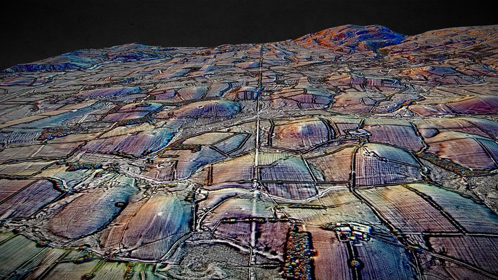
SD67 (dsm) - 3D LiDAR landscape
von NOWTAG
KostenlosCC BYSketchfab
100 sqkm enhanced LiDAR centred on SD 6500 7500 between Kirkby Lonsdale & Ingleton in Westmoreland (Cumbria) and North Yorkshire. Includes part of the Yorkshire Dales National Park. 3D model from enhanced LIDAR (DSM, 1m) © Environment Agency copyright and/or database right 2022. All rights reserve
Dieses Design wird auf Sketchfab gehostet. Die Dateien werden dort unter der angegebenen Lizenz heruntergeladen.
| Lizenz | CC BY |
|---|---|
| Quelle | Sketchfab |
| Designer | NOWTAG |
| Namensnennung | NOWTAG on Sketchfab · CC-BY 4.0 (attribution required) · Attribution required |
| Tags | landscape, lidar, dsm, cumbria, archaeology, yorkshire-dales |
100 sqkm enhanced LiDAR centred on SD 6500 7500 between Kirkby Lonsdale & Ingleton in Westmoreland (Cumbria) and North Yorkshire.
Includes part of the Yorkshire Dales National Park.
3D model from enhanced LIDAR (DSM, 1m) © Environment Agency copyright and/or database right 2022. All rights reserved. Vertical exaggeration x1.5
Enhancement of the LIDAR was carried out using tools made available in the QGIS plugin, Relief Visualization Toolbox. Kokalj, Žiga & Hesse, Ralf. (2017). Airborne laser scanning raster data visualization: A Guide to Good Practice.
3D landscape model made using the QGIS2threejs plugin for QGIS.
Veröffentliche deine Designs
Lade STL-, 3MF- oder OBJ-Dateien in der App hoch. Jeder Upload wird geprüft, bevor er hier erscheint, und Designer behalten 80 % jedes bezahlten Verkaufs.